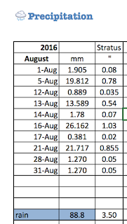
This is my monthly archive of precipitation data. September is here.
Aug. 31
Heads up, #Ottawa. Some heavy showers (and isolated t'storm activity) is nearby. Stay alert. pic.twitter.com/G0ykkwEfID— Kyle Smith (@KylesWeather) August 31, 2016
Rain, thunder and lightning & another 1.2 mm
My kids were canoe camping in Algonquin Park, thankfully they didn't have any storms! |
| AUGUST |
 |
Windsor had it, but it didn't make it here!Aug. 28 One whole mm! |
Aug. 27
Line of showers/storms moving into SW #Ontario and #Windsor is in a svr t-storm warning @weathernetwork #ONwx pic.twitter.com/eccXAvBQmx— Ross Giarratana (@RossGTWN) August 27, 2016
Aug. 25
SEVERE THUNDERSTORM WARNING extended to include Kitchener & Cambridge area. Major routes will be wet heading west. pic.twitter.com/51GC2vWJU8— Jay Scotland (@JayScotland) August 25, 2016
Tornadoes Aug. 24th
So far no injuries reported but a scary scene in southwestern Ontario earlier this evening. https://t.co/rFIF1sCYZ1— Jay Scotland (@JayScotland) August 25, 2016
Aug. 22
Aug. 21
 |
| Wonderful rain! |
Aug. 20th Clouds, no rain
Aug. 16th Finally! We had 26 mm!!!
 Sadly, there are many without power in the 'Lake Effect Snow' area, west of Georgian Bay this morning, Aug. 17th.
They anticipate getting them back up by midnight Aug. 17th,
Slight risk of flash flooding tomorrow with heavy tropical rain moving into S. Ontario #onstorm 20-40mm rain likely pic.twitter.com/szUPzXD7Kh— Ontario Weather (@OntarioWx) August 15, 2016
Aug. 15th Storm on the way!
They predict 50mm rain for us for Tuesday. We'll see. We are usually the 'stone in the river.' Where the clouds dissipate before they get here. I do hope more rain is on its way. Too many fires about.
 |
| storms acomin' |
Aug. 13th Severe Storms in Ontario
Aug. 25 Tornadoes yesterday. Seriously.
Not as much as they'd predicted...
#onstorm #Toronto future radar storms today .. details on theweathernetwork tv pic.twitter.com/6iJhyNGFYU— Chris St.Clair (@cstclair1) August 13, 2016
RVCA Update: SEVERE DROUGHT
Water levels in the Rideau Canal reservoir lakes, Bobs, Wolfe, Upper Rideau and Big Rideau, are about 30 centimetres below what are typical for this time of year. The lake levels now are what is usually seen in late September - early October on three of the lakes.
Levels on non-reservoir lakes have also continued to decline assisted to a large extent by evaporation of as much as 2.5 cm per day due to the recent 30 degree temperatures. Boaters on all lakes will need to be careful to avoid newly exposed shoals and rocks as levels drop.
It's time to cut back:
Levels on non-reservoir lakes have also continued to decline assisted to a large extent by evaporation of as much as 2.5 cm per day due to the recent 30 degree temperatures. Boaters on all lakes will need to be careful to avoid newly exposed shoals and rocks as levels drop.
It's time to cut back:
Typical residential indoor water use breakdown across the United States and Canada is:
Toilet
|
24%
|
Leaks
|
12%
|
Shower
|
20%
|
Other
|
4%
|
Faucet
|
19%
|
Bath
|
3%
|
Clothes Washer
|
17%
|
Dishwasher
|
1%
|
* Source: Water Research Foundation, http://www.
Aug. 12th
 We're the "stone in the river." The rain clouds dissipate before they get to us on land, farther away from the Great lakes.
You can check forest fires in Ontario
 |
| Ontario Forest Fires |
There have been four, to date.
You can check drought conditions in Quebec, and in Ontario.
Aug. 5th
What a lovely storm! We were away, but my daughter checked the gauge!
On my way back to #Ottawa. Going to try to head through this. pic.twitter.com/041v1BJmij— Kyle Smith (@KylesWeather) August 5, 2016


1 comment:
We still need more rain. And lots of it.
Post a Comment