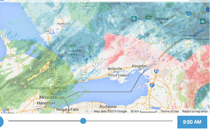
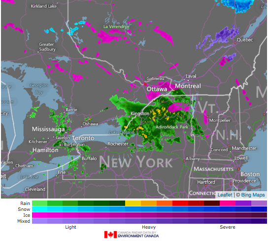
Dec. 31 Out like a snow storm!
 They warned us of 10 - 15 cm, but it was only 3 or so!
Dec. 30 Just a skiff
I think it a shame when journalists become weather forecasters. As if weather is coming to punish us! This is no better than the battle imagery for those managing cancer. It just is. Deal with it. Prepare for it. Learn about it.


Dec. 29 - anticipation!
WEATHER BOMB: moves into Atlantic Canada starting Thursday evening, expect snowfall & wind warnings to be issued @weathernetwork pic.twitter.com/Nggf5KIxTW— Jeff Harrington (@JHarringtonTV) December 28, 2016
Dec. 28 – 3 cm snow overnight
I gathered some snow in the rain gauge, and it's amazing the 3cm of snow translates to 0.08 mm of water. The point is, that we are getting regular precipitation, and I had to add cells in the chart below. We are in a moderate drought, now.
Dec. 27 – ice pellets, then rain (17 mm)
Toronto was a mess with a flash freeze.Outstanding job tonight by emergency crews working in treacherous conditions. Dozens of patients to hospital from various pileups. #onstorm pic.twitter.com/dvVHMGG7FG— Jeremy Cohn (@JeremyGlobalTV) December 28, 2016
VIDEO: Freezing drizzle wreaks havoc on Hwys 427 and 410. 45+ vehicles damaged, 20+ people to hospital from separate pile-ups. #onstorm pic.twitter.com/ydQjn0xxUO— Jeremy Cohn (@JeremyGlobalTV) December 28, 2016
Yes, our snow cover is greatly diminished, and what a lot of rain.
My birthday plans were cancelled, and the were vehicle incidents all over. What a surprise to have RAIN.

Me: "2 snow plows, an ambulance and a dozen tractor trailers have been in MVCs today."— Make It Home YGK (@YGKTraffic) December 26, 2016
Ppl: "How's the road to the mall?"
Me: "..."
Dec. 26th – predicting freezing rain, but it's -10 C. out there!

Ice pellets... 9:00 a.m.


Dec. 25 – horrid-looking warnings!
A series of #Winter weather alerts blanketing the #US and #Canada. #FreezingRain starts tomorrow in #Ontario #Onwx pic.twitter.com/1xEPtNqySa— Ross Giarratana (@RossGTWN) December 25, 2016
Dec. 24th – lovely snowfall: 4 cm

Dec. 22 – gentle snowfall 8cm

Dec. 18th – Tis a mess out there!
This guy slid right off the Rd. (Nepean). Get ready for more cold. -7° now but W wind ⬆️30 to 50 as temps⬇️. Low -22 pic.twitter.com/SzMkwrRJKB— Ian Black (@BlacksWeather) December 18, 2016


Dec. 17th Prediction
Ontario is a mess!Here is the latest on what to expect from Saturday's storm. pic.twitter.com/2nT5SK92G1— Ian Black (@BlacksWeather) December 16, 2016
#Hwy11 SB abt 2km from High Falls Rd exit. 2 vehicles in ditch. Some traffic delay. @townhuntsville @Townbracebridge @Gateway2Muskoka pic.twitter.com/jJotho7lXW— CogecoTV Muskoka (@cogecotvmuskoka) December 17, 2016
Dec. 16th – a warning
Snow Saturday possibly changing to freezing rain Saturday night. A Colorado low is expected to bring a large shield of snow with it, with snow arriving Friday night then continuing into Saturday. Such weather systems typically bring 15 or more centimetres of snow with them, and this one appears to be no exception. However as the low pressure area gets closer, there is potential for the snow to change over to freezing rain and ice pellets for at least a few hours Saturday night.
Eldorado Satellite
The freezing precipitation will then change back to snow in the wake of the low on Sunday. There remains some uncertainty to the exact track of this low. A small change in the track will affect the location of the heaviest snow, and whether or not the snow changes over to freezing rain. Deteriorating winter travel conditions are expected after the snow arrives Friday night.
Then there is the long john index!
Eldorado Satellite
The freezing precipitation will then change back to snow in the wake of the low on Sunday. There remains some uncertainty to the exact track of this low. A small change in the track will affect the location of the heaviest snow, and whether or not the snow changes over to freezing rain. Deteriorating winter travel conditions are expected after the snow arrives Friday night.
Then there is the long john index!
Good Morning Bonjour Canada! Here is your #longjohnindex Weather Map for a very cold December 16, 2016 https://t.co/uWXCSTS9Ew pic.twitter.com/RX9xaNZloF— the Long John Index (@longjohnindex) December 16, 2016
Dec. 15th – It's a cold one
Central and south Ontario has been hard hit. Muskoka's school busses were cancelled. December is a bad month in Muskoka, that Lake Effect Snow! The roads are all iffy!
Avoid unnecessary travel in areas impacted by snowsqualls. If you must drive, check our Highway Conditions Map first https://t.co/XfeEAo0LEy pic.twitter.com/TxLRryOZ14— The Weather Network (@weathernetwork) December 15, 2016
Crazy #snow❄️ #weather #driving on the 400 & 124 @AlmaguinNews @Muskoka411 @wc_parrysound #drivesafe @PSoundTourism @ParrySoundNS @OPP_News pic.twitter.com/NcW5x4gnSq— Opspeculate (@opspeculate) December 15, 2016
Beauty just outside my window. pic.twitter.com/RVMGzCvQCD— Ellie Thorel (@elmuskoka) December 15, 2016

My friend, in Huntsville, had 79.5cm!
Messy weather looms https://t.co/z33byFh4BD pic.twitter.com/LSr03lZihA— Quinte News (@quintenews) December 15, 2016
 |
| Just a skiff of snow! |

Dec. 13th – a warning!
First polar air of the season moving into S. Ontario tonight. Will likely see a couple snow squall bands develop ahead of the arctic front. pic.twitter.com/Gxm5mBdxWW— Andy Costa (@AndyBlizzard87) December 14, 2016
Significant Lake Effect will impact Central Ontario next 48h, 4-km NAM has up to 2+ feet at 10:1 ratios, 4+ feet at Kuchera ratios. #OnWX pic.twitter.com/1EBeRot9BP— Ontario Weather (@ont_weather) December 14, 2016
Dec. 12th – 13.75 cm our total!
#onstorm #onwx Here's a map showing the snowfall accumulations that we have recieved so far throughout Southern Ontario. pic.twitter.com/814qLbV1I5— OntarioBlizzardWatch (@OntarioBlizzard) December 12, 2016
 |
| big storm! |
Dec. 11th – a snow accumulation warning
,/div>It's a pretty blue on the radar, rolling in!Expected snow totals #onstorm see more on TheWeatherNetwork on tv pic.twitter.com/KK0VmOIrtt— Chris St.Clair (@cstclair1) December 11, 2016

Dec. 10th – Snow on the way? Lake Effect Snow

Dec. 9th -Holy Hannah! Where are your longjohns?
Colin McIntyre does the longjohn index. What a card!Still much lake effect snow, with the winds blowing across the Great Lakes.Good Morning Bonjour Canada! Here is your #longjohnindex Weather map, plus a gaggle of requests, for Dec 9, 2016 https://t.co/KkofGA8lte pic.twitter.com/YjOMaP2Sf9— the Long John Index (@longjohnindex) December 9, 2016


Dec. 6th - how much snow?
A list of final snowfall totals from around the region from Env Canada. pic.twitter.com/Cf50NGqScr
— Ian Black (@BlacksWeather) December 6, 2016
DEC. 5th 13.75 cm
DEC. 4th more warnings

DEC. 3rd: Fair warning!
Check out this beautiful animation of the arctic blast and weather pattern shift across North America starting next week. pic.twitter.com/EDDKdPuiHR— Andy Costa (@AndyBlizzard87) December 3, 2016
Dec. 2nd - 0.5mm
DEC. 1st How bizarre! 16.51mm rain...
They're really getting hit in the Maritimes!