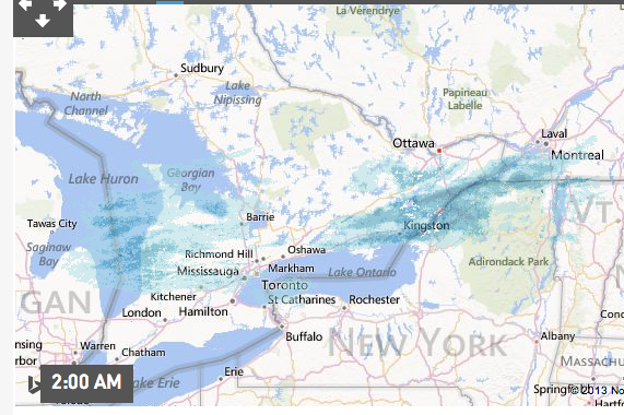
Jan. 29 snowfall - 30 cm between the big ice storm, and now! There is 54 cm on the ground.
 |
| had to shovel snow. |
| 2013 | ||
| JAN | snow | |
| cm | ||
| 4-Jan | 7 | |
| 6-Jan | ice rain | |
| 7-Jan | 5 | snow |
| 9-Jan | 7 | |
| 18-Jan | 8 | |
| 19-Jan | 5 | |
| 27-Jan | 30 | |
 |
| Wind warnings, indeed |
Jan. 23
More snow.
 |
| Jan. 22 |
 |
| Cold weather predictions |
 |
| jet stream hauls down the cold |
Jan. 21 - What a cold morning!
 |
| Jan. 20 |
Wind chills of minus 30 to 35 tonight and tomorrow morning. An Arctic airmass has settled over Southern Ontario. The combination of cold temperatures and moderate northwesterly winds is expected to produce wind chill values minus 30 or colder. Areas east of a line from Port Carling through Haliburton and Kaladar to Brockville - Leeds and Grenville wind chill values could reach minus 35 or colder.
Jan. 18 - 6cm

Jan. 16th - checked the metre stick, and after last week's melt, we've gone down to about 24cm snow base.
Jan. 9 - 12cm, on top of about 31 cm of a snow base.
| Jan. 12 |
Jan. 10
A band of freezing rain associated with a warm front will move into the regions from the south tonight. The latest indication is the freezing rain will begin late this evening and end overnight. Depending on the speed of the warm air moving northward the regions may receive 2 to 6 hours of freezing rain. The estimate for ice accumulation on surfaces is 2 to 5 millimetres. Motorists and pedestrians are advised to exercise caution especially on untreated surfaces. Local power outages are possible due to the ice accumulation.
Jan. 6 big melt
What a mess. The Maritimes have had 35,000 without power, this month, from their ice storm, and then dump of snow (30cm?). Toronto has blowing snow, following a melt. We, in SE Ontario, have rain, and 5+ C. temperatures. The eaves are dripping with melting snow. Buses cancelled for school kids.Happy cats are outside hunting for mice.


No comments:
Post a Comment