
I saw some signage for 'Jones Falls', on May 7th, We went for a drive.
What the heck. I thought it might be good for photos. It was a bit of a convoluted drive to find it. We began on one side, accidentally.
Since then, the dams need refurbishing. They are pouring money into the canal:
Parks Canada spending $40M to shore up crumbling Rideau Canal. I documented the work! There is a huge project on, I've written about the Poonamalie Locks, Narrows Locks, for example.


Of course, the Rideau Canal system was created to defend Canada from the US., and during the 1837 rebellion. It was meant to transport arms and troops, in the event of a war. it was a sturdy set of buildings.


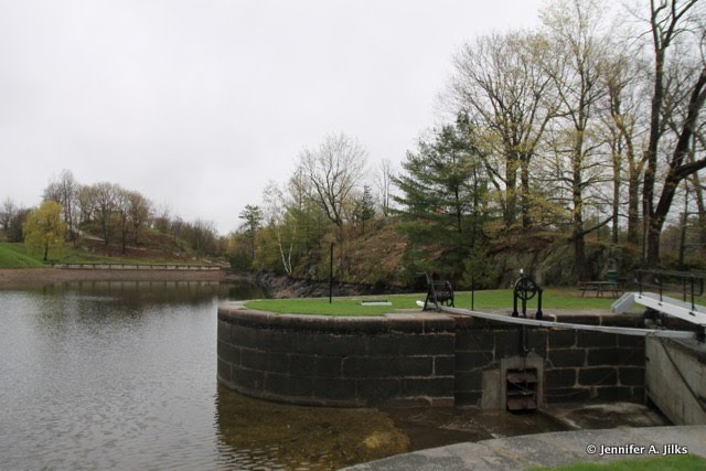


We decided to skootch around to the other side of the dam, to see the waterfall. Gilian GPS showed me how to get there. Sadly, this isn't accessible for we civilians. Closed for repairs, anyway.
 The sound of the rushing water was amazing, but we couldn't see it. It turns out it isn't Jones Falls, so much as Jones Pipes. The water goes through two large pipes. This was hubby's witty comment.
Rideau Canal: Jones Falls Lock station - Locks 39-42. You can read the full history of Jones Falls Lock station here. Sadly, a lot of the interpretive facilities were closed in 2012.
At the above website, they explained that the rapids were named for Charles Jones, of Brockville, although he never lived there.
In December of 1831, a letter is written by John Redpath, the contractor, explaining that construction had to be stopped for 3 months every year due to malaria issues.
There were 260 workers, including 40 stone masons. They were Scotsmen and French Canadians. About 2/3 of them were taken down by malaria for over a month. They were housed in nearby camps, with the officers and staff of the Royal Engineers in their own camp.
 |
Thomas Burrowes, watercolour, Archives of Ontario This dam blocked off the original channel of the White Fish River at Jones Falls. Visible at the left rear of the painting is a road on the far side (west) of the channel leading to pits where clay and gravel were excavated to form the front apron of the dam. Small carts were used to transport this material, across a bridge, to the dam. Part of this bridge can be seen behind the gap of the upper sluice. |
The power plant below the dam was built in 1947. Timber sluiceways were connected to a weir cut through the west end of the dam. The power plant is operated today by Granite Power.


The dam is 60' high. It's tough getting a photo of the height. There is a 6' concrete base sunk into the bedrock.


7 comments:
Lovely shots!
Projects and lots of money poured into them always raise our hopes for better infrastructure, better times. And Hope is something we constantly need to have in our life.
I think of the massive engineering feats accomplished without the technology available today, Machinery, GPS, and supplies all would make the tasks so much easier.In Southland, here in NZ, the Homer Tunnel was constructed in the 1930's and'40's. A massive feat, avalanches, stoppages for WW2, I will do a post on it soon. Love your outing, where was the " Jiggity-jig" as you drove home again? I always so enjoy that phrase.
I've never been down that way. I've seen it on the maps though.
What will Canada build now to protect itself from the US? - Margy
I didn't know the purpose of the rideau canal.
they made some amazing structures 200 years ago.
It's good that they are maintaining the canal as well as possible.
Post a Comment