Jan. 31st
Jan. 29th – a gentle snowfall
Jan. 28th – another wee skiff
Jan. 27th – a wee drift of snow
Jan. 24th – on it's way?
Poor Ottawa!Icy conditions blamed for messy 5-car crash on Colonel By. No serious injuries. Be careful. https://t.co/7tB1ooEB2g #ottnews #otttraffic pic.twitter.com/Bzppq4K6Qc— Ottawa Citizen (@OttawaCitizen) January 24, 2017
We have had ice pellets at 7:00 a.m., then it flipped from that to rain, to snow, pellets, snow!
Sorry.. Snow isn't cancelled (buses are), just delayed. ❄️has just started at the airport (6:40am). Windy & snowy today. 7-12cm. High -2. pic.twitter.com/67gUQEQyCr— Ian Black (@BlacksWeather) January 24, 2017
Jan. 23rd – Tornadoes down south, we're in for snow.
18 dead across #Georgia & #Mississippi, severe storms spawned multiple tornadoes. Hundreds of bldgs damaged/destroyed @AMHQ @weatherchannel pic.twitter.com/T6uei44FF2— Anaridis Rodriguez (@Anaridis) January 23, 2017
Low pressure circulation also evident in the regional radar mosaic loop pic.twitter.com/VDUxP6tSlO— NWS Memphis (@NWSMemphis) January 22, 2017
Jan. 20th – looks like a swirling mess
As seen in this GOES infrared imagery, rain & snow will continue in the West and storms are likely in the southeast: https://t.co/9x3XwUGK4B pic.twitter.com/ft6562Gfm7— NOAA Satellites (@NOAASatellites) January 20, 2017
Jan. 18th – A few cm snow, and then rain all night
I was worried about visiting my client. The radar showed something coming, the question: when! It was fine when I left. I was due to leave her place at 4:00, and at 3:45, the snow just dropped like a curtain. Big, fluffy flakes. Eventually, it changed to rain. The sidewalk is all ice.
Jan. 17th
And here it comes! The question: will it be rain, snow, sleet or hail?! The blue is snow, the pink the ice rain, the green rain. Sigh.
Track My Plow shows a mess!
Wicked
FREEZING RAIN risk late Monday before the sun rises on Tuesday for areas of Ontario as weather maker pushes up from U.S. @weathernetwork pic.twitter.com/vCPfFnVUDJ— Jeff Harrington (@JHarringtonTV) January 14, 2017
Jan. 15
Poor Oklahoma. Freezing rain...Most of the trees around Buffalo, OK are a mangled mess. #okwx #icestorm2017 pic.twitter.com/9SNBhJomNQ— Basehunters Chasing (@Basehunters) January 15, 2017
Jan. 14th–a cold one!
Jan. 12th – rain overnight
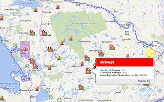
More Hydro outages.Jan. 11th – Winds are wild. Temperatures 5+ C., rained!
UPDATE 10:00 a.m.:Crews continue full restoration efforts on 471 outages affecting 53,703 customers. For updates, visit: https://t.co/MHdZ6xZVbG #ONstorm pic.twitter.com/doRxSQxIVM— Hydro One (@HydroOne) January 11, 2017
Strong winds caused more outages throughout the night. Crews continue to work hard this morning to restore power to 59,000 customers.
Jan. 10th – We'll see what this brings us!
Jan. 9th – "Vorticity"
Tropopause potential T anomalies -- little fuzzy white balls of vorticity over next 3-days highlight location of coldest, polar vortex air pic.twitter.com/XwezzlHaFV— Ryan Maue (@RyanMaue) January 9, 2017
Yesterday was amazingly cold, but sunny. I hauled some wood. Today, looks like some snow. Sure won't be rain!!!


Jan. 7th - 2.5 cm light snow
Jan. 6th – we cannot complain!
Look at the Muskoka region... Lake Effect Snow! The winds pick up the moisture from the Great Lakes.Moisture sweeps across the atmosphere in this GOES composite water vapor imagery of the past 72 hours. See more at https://t.co/V5x34CI4KX pic.twitter.com/XOLeBPDkSH— NOAA Satellites (@NOAASatellites) January 6, 2017
My friend, Jenn's dog in their snow!
We're just cold in southeastern Ontario. This morning it was -17 C. or so....and we received another 20cm+ after this pic was taken 👍😀 Happy Friday friends 😘😘 pic.twitter.com/lbXcLIrZ5k— jennifer (@jenn1662) January 6, 2017
Muskoka got 80cm you heard me 80cm since last night of Snow! pic.twitter.com/dtr2KM08J5— MusicR_ Photography (@MusicR_Photos) January 6, 2017
Jan. 5th
Crews continue to work on the remaining 5,607 customers still affected by yesterday's storm. Please visit our outage map for local updates— Hydro One (@HydroOne) January 5, 2017

Hydro Ottawa has made progress, this morning only 25 left to get back up and running. It's hard work.
Update - Crews continue to work throughout the night. 301 customers remain without power. Latest info: https://t.co/s9drRAf3l5 pic.twitter.com/a47ZqXIJF7— Hydro Ottawa (@hydroottawa) January 5, 2017
Jan. 4th – rain and snow!
There are 26,275 people currently without power according to Hydro One. 9:00 a.m. Wed.
That was a bit of a mess. Trees are a mess, covered in ice rain and then snow.
That was a bit of a mess. Trees are a mess, covered in ice rain and then snow.
Portrait of a cleanup: snowy, skinny streets, slippery sidewalks and, on top of it, hydro lines down at Gladstone/Lewis. pic.twitter.com/4MiLfUSOne— Andrew Foote (@amkfoote) January 4, 2017
TY linesmen & @hydroottawa staff working round the clock. #OttawaFire reminds residents to call if lines are arcing & stay clear #staysafe https://t.co/lrnK0UH4Yf— Danielle Cardinal (@OttawaFirePIO) January 4, 2017
Hydro out all over the region. Hydro Ottawa, and HydroOne (Ontario).
Hydro Ottawa crews working around the clock to restore power. #ottnews pic.twitter.com/i7Om6MRl9Z— Hydro Ottawa (@hydroottawa) January 4, 2017
Jan. 3rd –Freezing rain, slick driveway only -1 C.!
Freezing rain is ongoing across parts of E. Ontario this morning. Lots of rain coming today with over 25mm possible locally. #onstorm pic.twitter.com/RQcIYdLCt0— Andy Costa (@AndyBlizzard87) January 3, 2017
The patterns are interesting!
Jan. 2nd
Warnings for usTropopause potential T anomalies -- little fuzzy white balls of vorticity over next 3-days highlight location of coldest, polar vortex air pic.twitter.com/XwezzlHaFV— Ryan Maue (@RyanMaue) January 9, 2017
Freezing rain warning issued for eastern Ontario. Significant ice could cause slick roads and outages on Tuesday. pic.twitter.com/0RFl2HhMJy— Anthony Farnell (@AnthonyFarnell) January 2, 2017
ALERTS for weather maker moving in late this afternoon, snow ramps up late tonight for S. Manitoba & NW Ontario PLUS freezing risk pic.twitter.com/hxoE5ntr6I— Jeff Harrington (@JHarringtonTV) January 2, 2017
#onstorm #onwx Here’s our freezing rain forecast starting Monday night. Rain to follow will melt ice quickly. Info: https://t.co/qiQuTCrxNH pic.twitter.com/dOSYeyFFtW— OntarioBlizzardWatch (@OntarioBlizzard) January 1, 2017


